
From Michelin Guides to the Military Mapping Maidens

I am finally getting ready to publish this new historical novel I’ve been working on titled, Whiskey Creek, and I wanted to share more about where I got the ideas for this book. Previously, I wrote about the Hooligan’s Navy, the Americans who set out to patrol our coast for U-boats.
Today, I want to write about how I like to give my characters a certain strength, or superpower. For Annie, the main character of my new novel, it is navigation and mapmaking or cartography.
I once dreamed of sailing solo around the world. I knew I needed to learn celestial navigation, so I flew to Hawaii looking to crew on a boat heading south. I found that boat in a Lapworth-designed Islander 44, and in 1975, I set sail across the Pacific to New Zealand, then back to California with Jim Kling (who later became my husband). We navigated with a sextant, a chronometer, a nautical almanac and multiple volumes of the H.O. 229 Sight Reduction tables. For my last ocean crossing in 2023, I sailed across the Atlantic on our M/V Möbius with digital charts of the world, several GPS heads, and a satellite compass. Obviously, I’ve seen a huge amount of change in the world of cartography in my lifetime, and it fascinates me.
Whiskey Creek is a World War II novel that takes place mostly on the Homefront, so in addition to the Hooligan’s Navy, I decided that Annie would become a war-time cartographer. For me, that meant I got to go to my happy place — research. Now, before I get into the role of women in the Army Map Service, let’s do a quick flyover on the history of maps and charts.
For centuries, mapmaking was mostly a maritime obsession. The fastest and most expedient method of transporting people and goods was on the water. The famous Portolan charts of the 13th century were great at showing the sea and coastlines to ensure ships didn’t crash into continents. They told you direction, but they didn’t tell you depth or height. And if you turned your eyes inland on those charts, the detail vanished.
The thing that makes navigating on the ocean easier in some ways is that it is a flat plane. Two dimensions. It wasn’t until the mid-19th century that cartography began to conquer the third dimension.
American and British mapping offices finally moved beyond just “water” and “land,” and began adding soundings (depth measurements) to keep hulls from hitting the unseen hard bits lurking below the surface, and spot elevations for coastal landmarks like cliffs and lighthouses. This allowed navigators to use trigonometry (with a sextant to measure the angle) to determine exactly how far they were from shore. If you were a ship captain in 1900, you had excellent charts of the water and the coastline.
But nautical charts still stopped at the shoreline. Interior road maps were just starting to appear. When World War I erupted, this lack of interior detail was manageable. WWI was a static war fought by line-of-sight; if you could see the enemy, you could shoot them. The range of their artillery was limited. Armies sat in trenches for years. This gave surveyors time. If troops needed to fire over a hill, you sent a surveyor to measure it first. And since the war was mostly static, the fact that all the European nations had their own internal map-making methods was not an issue. Vast swathes of the world were still only mapped in two dimensions (X and Y) showing roads and towns, but missing the crucial Z-axis (elevation).
World War II changed the math entirely. This was a war of movement (Blitzkrieg). New Howitzers (like the U.S. 105mm and 155mm) could fire shells 7 to 15 miles away. Suddenly, gunners were firing at targets they couldn’t see, over terrain they had never visited. They needed the “Z-axis.” If a map failed to show a village’s elevation, a shell meant for a Nazi bunker on the other side of a hill might slam into a school. Without accurate contour lines (elevation data) on a map, long-range artillery is blind.
When the United States entered the war, the U.S. had decent 3D maps of America and the UK had decent maps of England, but the Allied intelligence on the interior of Europe was disastrously thin. The most accurate source of data they had for many regions was not military intelligence, but Michelin Guides (yes, the tire company restaurant guides) designed to help vacationers find a good hotel, not to help a tank commander navigate a ridge or an artillery officer calculate a trajectory. Even when the Allies captured enemy maps, they were useless for American artillery.
The French used the “Bonne” projection; the Germans used the “Gauss-Krüger” grid; and the Americans used the “Polyconic” projection. It was a mathematical nightmare. You cannot fire an American gun using German map coordinates. The math doesn’t work.
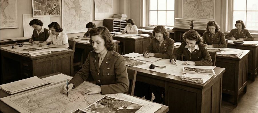
So, what do you do? The US military formed the Army Map Service (AMS) to solve this problem. And with the male workforce all being drafted to the front lines, the Army turned to an unlikely group of saviors: a recruited force of women with degrees in geology, math, and art. They were officially Army Map Service employees, but history would know them as the Military Mapping Maidens.
And theirs is such a cool story!
In a massive recruitment blitz, the Army Map Service sent scouts to women’s colleges and universities across the country, places like Wellesley, Mount Holyoke, and the Big Ten schools. They weren’t just looking for warm bodies; they were hunting for specific intellectual skill sets. They recruited geology majors who understood terrain, math majors who could handle the complex trigonometry of grid conversions, and art majors who had the skill and eye for detail required for drafting.
These women moved to D.C. to live in crowded boarding houses and went to work each day creating the thousands of maps the Allies needed. Some were sent out to search libraries and universities for any maps of Europe (tourist maps, old German maps, hydrographic charts). Others figured out how to do the tedious work of grid conversion, and how to add the missing elevation data. They had to mathematically overlay the “Universal Transverse Mercator” (UTM) grid, the standard Allied system, onto these foreign maps.
Before these women could pick up their drafting pens to draw all the new maps that would be needed for D-Day, someone had to go get the data. Photography and aircraft had come a long way since WWI. The Army realized early on that a lumbering bomber vibrated too much for precision photography and was too easy a target. So, they took their fastest fighter, the twin-engine P-38 Lightning, and stripped it of every single machine gun and cannon. In the empty nose cone, they packed five massive mapping cameras.
Renamed the F-5, these planes flew “Trimetrogon” missions, snapping three simultaneous photos that stretched from horizon to horizon. To get the overlapping images the Map Maidens needed for their 3D work, these pilots had to fly perfectly straight lines over anti-aircraft batteries, completely unarmed. Their motto was “Alone, Unarmed, and Unafraid.” Because they carried no weapons, these pilots relied entirely on speed and altitude, sometimes as high as 30,000 feet. If they were intercepted by a German Messerschmitt, they couldn’t fight back; they could only try to outrun it. The pilots provided the raw intelligence in the form of photos; the women in Washington provided the precision.
Back in the drafting rooms, the women used massive projectors called Multiplexes to shine these overlapping photos onto their drafting tables. Wearing special 3D glasses decades before they were cool in movie theaters, the women could see the flat photos pop into three-dimensional terrain. They would then trace the contour lines that would show the elevations in order to guide the artillery.
By the time Allied troops hit the beaches of Normandy on June 6, 1944, the Army Map Service had accomplished the impossible. For the D-Day invasion alone, the Mapping Maidens and their colleagues had produced and shipped roughly 70 million maps.
It is easy to look at the images on our chart plotters today and think of it as a satellite miracle. But GPS is more than just satellites in space; it is a mathematical model of the earth using the science of geodesy. The work these women did set the stage for the next and the final bit of true history that I wove into Whiskey Creek. That is the story of the secret mission to grab all the Nazi map data at the end of the war. Stay subscribed to hear about that one!
Great News: Whiskey Creek is available for pre-order!

Finally!
Another Christine Kling masterpiece!
Great historical narrative here. The shift from 2D portolan charts to 3D contour mapping duirng WWII really captures how warfare drove cartographic innovation. The grid conversion problem is underappreciated, different projection systems made captured maps useless for targeting which forced that massive AMS standardization effort. The Michelin Guide detail is wild, basically tourism infrastructure becomming military intellignece by default.